


Le Rozier - Premier jour

GeorgesV.
User
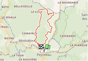

Length
18 km

Max alt
948 m

Uphill gradient
722 m
Km-Effort
28 km

Min alt
389 m

Downhill gradient
720 m
Boucle
Yes
Creation date :
2024-04-23 10:32:33.0
Updated on :
2024-04-23 17:21:08.058

FREE GPS app for hiking
 SityTrail
IGN / Geographical institutes
SityTrail Plus
The world is yours!
About
Trail of 18 km to be discovered at Occitania, Lozère, Le Rozier. This trail is proposed by GeorgesV..
Positioning
Country:
France
Region :
Occitania
Department/Province :
Lozère
Municipality :
Le Rozier
Location:
Unknown
Start:(Dec)
Start:(UTM)
516643 ; 4893069 (31T) N.
Comments